Looking to do a basic elevation map of your farm to assess drainage patterns? Wanting to measure the volume of a gravel pile with your DJI Phantom? Needing to generate a detailed 3D model of a building using just a Mavic Pro?
You will need two things: a mapping drone, and some robust drone mapping apps or software.
Having this eye in the sky allows for very quick turnaround times, typically much quicker than an on-the-ground inspection could provide.
Although drones have been taking great aerial images for years now, many industries were looking for advanced mapping and surveying options.
Only until recently have the mapping apps come around to the point where they provide accurate and timely data analysis and flight programming for a reasonable and accessible cost.
We have compiled a list of the top 11 drone mapping software available on the market today (and more specifically, mapping software that is compatible with DJI drones, the current market leader in consumer UAVs).
We list their strengths and weaknesses, current pricing & pricing models, and overall ease of use.
[Please note, although we originally thought of ranking them 1-11, we decided against it as many of these apps are specialized in one specific area or another. Also please see our related post “Interesting Drone Apps You Need to Know About” which covers drone apps with various purposes, not just mapping.]
11 Drone Mapping Apps & Software You Should Know About
DJI Terra
DJI Terra is great mapping software for those looking to enter into the industry. Built by DJI, the world’s leading consumer drone manufacturer, it is straightforward and easy to use.
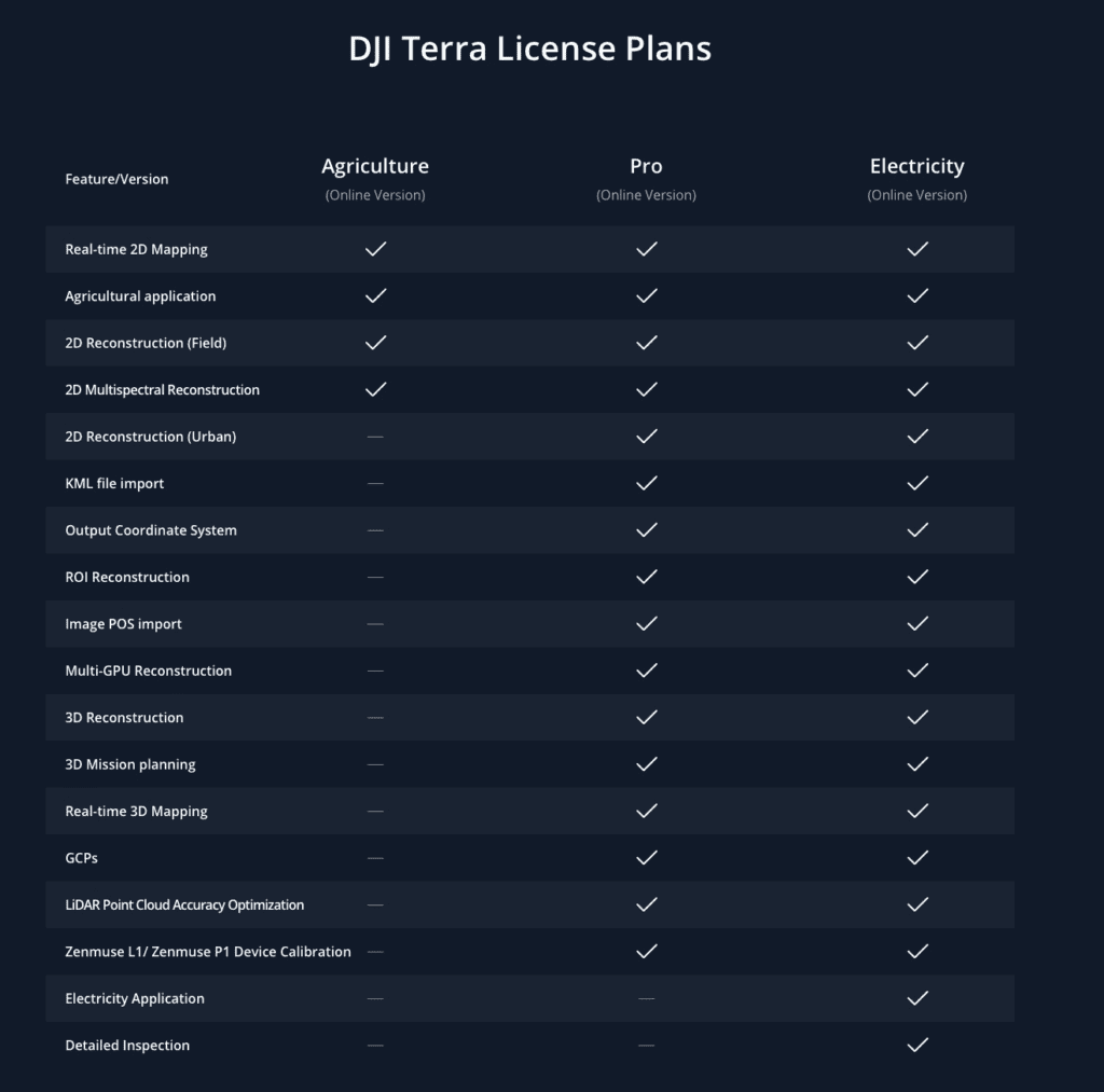
DJI Terra comes in three versions: Agricultural, Pro, and Electricity.
DJI Terra Agriculture is designed to let you generate orthomosaics of farmland, generate point clouds, measure distances and more. It starts at $300/year
DJI Terra Pro allows users to generate accurate 2D orthophoto maps and 3D models in real time during the flight, outputting the results as you fly. It also allows you to automate inspection workflows. It starts at $1500/year.
DJI Terra Electricity is the most expensive of the bunch (starts at $3080/year) but allows you to perform detailed inspections of electrical stations and infrastructure.
Strengths:
-Easy to use and integrates tightly with DJI Products
Weaknesses:
-Pricey annual subscription
Ease of Use:
8/10

Propeller Aero
Intended for more advanced drone users, Propeller Aero’s drone mapping software streamlines measuring and management routines into a one-man operation. It features universally compatible visual tools that can be used across multiple mainstream platforms like Apple, Android, and Windows.
This data mapping software is more geared toward industries that manage resources or civil projects. It is advertised as a tool for helping to calculate out on-site metrics, among other uses. The Propeller Aero drone mapping software excels in multitasking and can be used for checking progress in dig sites, managing inventory, and tracking changes in an efficient and affordable manner.
This makes Propeller Aero a very popular choice among commercial operators, as it has shown exceptional results when used in the construction, waste management, mining, aggregates, and surveying industries. Wherever a detailed outdoor recording is needed, Propeller Aero is where professionals go.

Strengths:
- Helpful for Team Efforts—Propeller Aero’s main strength lies in the fact that it is the ideal drone mapping software for coordinating team efforts.
- Efficient Data Coordination—It has a streamlined data collection and management system.
- AeroPoint smart ground control—Propeller Aero features patented smart ground control called AeroPoints, which is also the world’s first ground control point system tailor-made for drone surveying. AeroPoints are highly durable and can keep gathering data easily in extreme environmental conditions.
Weakness:
Not Ideal for Beginners—The only noticeable weakness of the product is it’s feature-rich interface is aimed at seasoned and experienced users and could take some training for new users to feel comfortable with. But Propeller does provides 24/7 customer support to lessen the learning curve.
File Export Formats:
- Densified Point Cloud (.las, .laz, .xyz, .ply)
- Digital Surface Model (Grid DSM, Raster DSM)
- Digital Terrain Model (DTM: Raster DTM)
- Orthomosaic (GeoTIFF, KML file, Google Maps HTML file)
- Index Map (GeoTIFF, Colored KML file, Grid Shapefile)
- 3D Textured Mesh (.obj, .fbx, .dxf, .ply, .pdf, .osgb, .slpk)
- Contour Lines (shp, .pdf, .dxf)
Ease of Use
9/10
Pricing Model:
Annual subscription.
Pricing:
The pricing model of the Propeller Aero is an annual price model based on the number of worksites.
The Annual Site license for a single worksite comes with unlimited user access, 15 data sets of processing per month, unlimited access to data analytics backed up by Propellers’ own backend system, as well as 24 months data retention.
The Annual Roving Site license allows for drone mapping operations in multiple worksites, support for up to 10 users, as well as all features of the single worksite subscription.
More customization and pricing models are available on Propeller Aero’s Official website.

DroneDeploy
Arguably the biggest name in the prosumer drone mapping industry, DroneDeploy has made big strides in the past years in terms of streamlining the mapping process, making their interface incredibly intuitive, and allowing for a wide range of applications with their 3rd party app market.
Their mapping app makes mapping with pretty much any of the DJI drones a breeze. Simply draw a circle or polygon around the area or object you would like to capture, set your desired resolution and the drone will do the rest!
Drone Deploy offers some great features inside their app, such as annotations, rapid map processing (photos go straight from your drone to DroneDeploy), real time volume/distance calculations and so much more.
Strengths:
One of the early players in the drone mapping industry, DroneDeploy has evolved from an often glitchy user interface to a smooth, streamlined option for drone mapping.
One of their major strengths is their app store which allows 3rd parties to interface with the collected aerial imagery and generate their own datasets.
DroneDeploy integrates with some of the big names in the ag industry (John Deere, Skymatics etc) and has some incredible apps available in their app store such as the Birds.ai app which allows automated crop counts and the EZ3D Roof app which allows for automated roof mapping to assess for damage and repair estimates.
Weaknesses:
DroneDeploy seems to have targeted the mass consumer/prosumer market and done so well. Some industry professionals feel that some of the other mapping options (such as Pix4D) provide a more accurate map and allows for significantly more control over the dataset than DroneDeploy does.
Among the professional surveying crowd DroneDeploy is viewed as great entry level tool, but when it comes to enterprise level data processing Pix4D appears to be a more robust solution.
File export formats:
JPG, GEOTiff, OBJ, Point Clouds, LAS, XYZ, Shapefiles, DXF, Contours, option to process GCPs.
Ease of use:
8/10
Pricing Model:
Monthly Fee (30 day free trial available)
Pricing Costs:
Pro Plan-$83USD/Month (includes up to 1000 images/map, JPG, GEOTiff, OBJ file exports, volume measurement and access to 70+ 3rd party apps in the DroneDeploy Marketplace).
Business Plan-$249/month (includes pro features + 3000images/map, email/chat support, point clouds, LAS, XYZ, Shapefiles, DXF, Contours, multi-user, and the option to process Ground Control Points (GCPs).
Enterprise Plan-Custom pricing. Includes all business features + 5000 images/map, dedicated customer support, API access, single sign-on, roles/permission, activity audit, data viewer, unlimited GCP maps, unlimited DTM, roof reports

Pix4Dmapper
Founded in 2011, Pix4D has close to a decade of aerial imaging and mapping experience. Their focus has been on the enterprise level crowd that demands the highest quality map available.
From the start they have been committed to assembling professional georeferenced maps built on years of academic research.
Originally Pix4D only offered desktop based solutions, but have recently launched their mobile Pix4D Capture app for both Android and iOS. Their original partnership with eBee still stands but they have expanded their software to interface with the ubiquitous DJI UAV systems. Cloud processing of their images is included in their different mapping packages.
Strengths:
Enterprise level mapping and inspection software with a solid team to back it up. Plenty of training material and a certification course are available. Hybrid user system (computer/cloud) is an excellent setup that allows users with high bandwidth to process images online but also allows users that are offline (for example, in the field) to process images locally on a laptop.
Weaknesses:
Targeted at advanced user and enterprise level customers demanding the best of the best mapping software, some users have stated their interface is not as intuitive as DroneDeploy.
File Export Formats:
- Camera parameters (Internal parameters, External parameters, Bingo, SSK): These files describe the internal (focal length,…) or external parameters (position and orientation) of the camera and images.
- Undistorted images
- Densified Point Cloud (.las, .laz, .xyz, .ply)
- Digital Surface Model (Grid DSM, Raster DSM)
- Digital Terrain Model (DTM: Raster DTM)
- Orthomosaic (GeoTIFF, KML file, Google Maps HTML file)
- Index Map (GeoTIFF, Colored KML file, Grid Shapefile)
- 3D Textured Mesh (.obj, .fbx, .dxf, .ply, .pdf, .osgb, .slpk)
- Contour lines (shp, .pdf, .dxf)
- Video animation (.mp4, .mkv, .avi)
- 3D Digitized objects: Polyline, Surface, Volume base surface (.shp, .dxf,.kml, .dgn)
Ease of use:
7/10
Pricing Model:
Subscription (monthly or yearly). Pricing starting at $42/month.
Pricing Costs Pix4Dmapper:
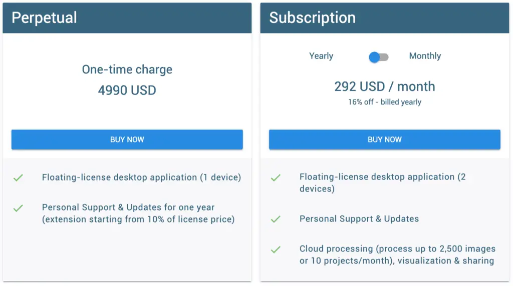
Several pricing options are available on the Pix4D site, including perpetual licenses for educational purposes. Further pricing can be found at: https://cloud.pix4d.com/store/

DJI Groundstation (GS PRO)
DJI is by far and away the leader in consumer and prosumer UAVs, and have the marketshare to prove it. GS PRO is their own app for planning UAV mapping missions. Although their app and software does not do any image processing, it does integrate tightly with all of their UAVs. It is currently only compatible with the Apple iPad.
Strengths:
As it is built by the manufacturer it works fairly seamlessly with their UAVs. Clean interface, intuitive.
Weaknesses:
Maximum of 99 waypoints which can be limiting for some professional users. Only compatible with DJI drones and the iPad. Some users say the software is not that polished and occasionally glitchy. Infrequent updates also seems to be an issue.
File Export Formats:
Does not export any files, mission planner only. Does import KML/SHP files for more accurate mission planning
Ease of use:
8/10
Pricing Model:
Free download, with in-app upgrade options available
Pricing Costs:
Free, in-app upgrades available

Raptor Maps
Raptor Maps has a strong focus on performing solar analysis and solar construction site monitoring, as well as generating reports for both.
Founded in 2015 by MIT engineers who were involved in SpaceX and advanced biomedical engineering, Raptor Maps has an incredible depth of knowledge and academia backing it.
Strengths:
Strong focus on thermal imaging and assessing solar (PV) panels. Their mission is to make it easy for solar companies to monitor and assesses performance of PV panels and to use their advanced artificial intelligence algorithms to detect and performance altering deficiencies.
As Raptor Maps does not require or use orthomosaics to assess photovoltaic systems their data requirements are around 80-90% fewer images than other services! Raptor Maps states that their customers are completing solar farm inspections up to 4X faster than competing systems that require orthomosaics.
Weaknesses:
When it comes to mapping PV panels Raptor Maps is unparalleled. It does not have the most intuitive of workflows, but the company is young and rapidly evolving.
Ease of use:
6/10
Pricing Model:
Custom, variable
Pricing Costs:
Raptor maps does not currently have publicly available pricing. Visit https://raptormaps.com/faq/ for more details.

Maps Made Easy
Maps Made Easy and DroneDeploy have been among the top contenders for ease-of-use and low barrier to entry.
Initially Maps Made Easy was the preferred of the the two due to its seemingly more accurate stitching algorithm and more reliable app. DroneDeploy has recently made some big changes to their workflow and now seems to have surpassed Maps Made Easy as far as ease of use and functionality.
The big plus that Maps Made Easy has going for it is the per-acre pricing, which is great for occasional users who do not want to sign up for yet another month-to-month subscription service.
Strengths:
Ease of use, some great options under the free package. Also, pay-as-you-go means you are not stuck in a month-to-month contract like you are with some of the others. Also great for processing massive jobs (allows for upload of up to 7500 images!)
Weaknesses:
Some users complain of occasional issues with multi-battery flights. Interface not as refined as some of the big players (DroneDeploy, Pix4D).
File Export Formats:
GeoTIFF (TIF), Full Resolution (JPG), DEM (TIF), Colorized DEM GeoTiff (TIF), Colorized DEM (JPG), 3D Google Earth (KMZ), Point Cloud (LAS), Point Cloud XYZ RGB (TXT), 3D Model (OBJ), 3D Material (MTL), 3D Texture (JPG). Also allows for iFrame embed codes to easily implement into blog or website.
Ease of use:
8/10
Pricing Model:
Pay-as-you go (no monthly subscription!). Uses a points based system.
Pricing Costs:
Uses a points systems that converts to a per-acre cost. Costs start as low as $0.022 per acre.
|
Price |
Points |
Approximate Coverage |
Cost (per acre) |
|
$7.99 |
300 |
120 Acres |
$0.067 |
|
$29.99 |
1,500 |
650 Acres |
$0.046 |
|
$54.99 |
3,000 |
1,350 Acres |
$0.041 |
|
$99.99 |
6,000 |
2,800 Acres |
$0.036 |
|
$149.99 |
10,000 |
5,000 Acres |
$0.030 |
|
$424.99 |
30,000 |
16,000 |
$0.026 |
|
$669.99 |
50,000 |
30,000 Acres |
$0.022 |
3DR Sitescan
One of the newer brands in the UAV market, 3DR Site Scan Software specializes in providing both hardware and software to both individual and enterprise clients.
The 3DR Site Scan software brings accurate on-demand positioning service that can be narrowed down to meters and centimeters, and is simplified by the use of an Android device and Site Scan Cloud Connectivity.
3DR Site Scan ensures that the captured drone photogrammetry is instantaneously uploaded to the cloud platform, waiting to be processed into point clouds, orthomosaics, and more with a few simple commands. The 3DR Site Scan drone mapping software is also highly compatible with Autodesk products. 3DR also recently announced that their backend engine is now powered by the Pix4D engine for increased accuracy.
Strengths:
- Tech Support – 3DR Site Scan has amazing tech support compared to its peers.
- Dedicated User Community – 3DR’s community-minded open platform has inspired the growth of a global developer collaboration like none other.
- Built For Data Analysis – Features like multi-engine processing, point cloud analysis, and volumetrics make Site Scan the ideal choice for teams looking for simpler data analytics.
- Real-Time Elevation Profiles – Site Scan is capable of drawing real-time elevation profiles based on drone generated data, automatically uploading them to the cloud.
- Compatible with both DJI and 3DR UAV platforms.
Weaknesses:
Does not have it’s own data processing, but tightly integrates the captured data with software such as Autodesk ReCap Cloud or AutoCAD, Infraworks, Revit and more.
File Export Formats:
Does not export files directly itself, but integrates with AutoCAD products for a wide variety of export options.
Ease of use:
6/10
Pricing Model:
Month to month, public pricing not available, contact them for exact pricing.
Pricing Costs:
Pricing not available online.
PrecisionHawk DataMapper & Precision Flight
These two apps go together. Precision Flight is used to plan your mission and is compatible with DJI Drones and their own PrecisionHawk fixed wing UAV. DataMapper is used to process the data from these flights into useable data.
One of the earliest and key players in the UAV industry, PrecisionHawk has made quite a name for itself in the agricultural sector thanks to its trademark PrecisionMapper feature that is not available in other drone mapping software.
The software also provides specialized metrics for monitoring and analyzing crop health as well as volumetric measurement. Thanks to all these features, this software is excellent for large-scale operations that require intensive and careful monitoring like farming, real-estate, and energy.
Subscription to PrecisionHawk DataMapper also allows access to their popular Algo Market, a library of algorithms and data analysis tools for almost any need you can imagine.
Strengths:
- More Options – DataMapper provides a large range of mapping options compared to most other drone mapping software.
- Algorithm Library – The large algorithm library provides algorithm solutions for almost any kind of situation imaginable. Some of the most notable and popular algorithms in PrecisionHawk Mapper’s algorithm library include a canopy cover calculator, NDVI enhancements, and a roof report generator. There are also several agriculture focused algorithms not found in other drone mapping software, like the one that locates all sources of standing water in a crop field.
Weaknesses:
- Complex Nature and Interface – Due to its complexity and algorithm variables, this drone mapping software is not user-friendly for beginners.
File Export Formats:
| Output Name | Output File Type | Required Software* |
| Georefernced Image | .tif | Software like QGIS, ArcGIS, etc |
| Digital Surface Model (DSM) | .tif | Software like QGIS, ArcGIS, etc |
| KML Files | .kml | Google Earth for KML file Any web-browser for HTML file |
| Point Cloud | .las | Software like ArcGIS, AutocadMap, GlobalMapper, etc. |
| 3D Model | .obj | Software like MeshLab |
| Contours | .shp | Software like QGIS, ArcGIS, etc. |
| Drawing Exchange Format | .dxf | Software like Autocad, ABViewer etc. |
Pricing Model:
Subscription (free and paid).
Pricing:
PrecisionMapper has two basic subscription models. Their models are as followed:
- Free – The free model comes with some with all the basic features including access to 300 GB storage limit, PrecisionViewer and Cloud based 2D/3D map generation. The free subscription does not come with sensor support.
- Professional – The paid subscription includes all basic features as well as sensor support options including visual, thermal, LIDR, and hyperspectral options. Pricing for the paid subscription of PrecisionMapper varies from region to region.
Agisoft Standard Version
Starting in 2006, Agisoft has come a long way. One of the few Russian tech successes in the drone industry, the Agisoft drone mapping software prides itself as the be-all-end-all solution to professional 3D modeling needs for drone mapping.
The software greatly benefits from panoramic stitching and the excellently integrated 3D modeling engine. Agisoft also provides support for fisheye lenses that are equipable with advanced drone models.
Although primarily intended for agricultural use, its top-of-the-line 3D modeling abilities and similar features have made it very popular among media professionals, architects, civil engineers, and GIS professionals.
Strengths:
- Powerful 3D Mapping Tools – Agisoft’s wide range of 3D modeling tools include thermal, NIR, RGB, and advanced multi-spectral image support.
- No Additional Charges – Agisoft provides access to high-quality professional imagery without any additional charges. What they offer is on par with the image quality provided by more expensive software.
- Effective – The software is highly capable of creating digital elevation models and point clouds, as well as taking accurate measurements.
Weaknesses:
- Specialized User Base – Compared to other drone mapping software, the user-interface is complicated and clunky and takes some time to get familiarized with.
- Linear Subscription Policy – Not very popular among corporate clients due to its “one computer, one user” subscription policy.
File Export Formats:
- Camera Parameters (Internal parameters, External parameters, Bingo, SSK)
- Undistorted Images
- Densified Point Cloud (.las, .laz, .xyz, .ply)
- Digital Surface Model (Grid DSM, Raster DSM)
- Digital Terrain Model (DTM: Raster DTM), Orthomosaic (GeoTIFF, KML file, Google Maps HTML file)
- Index Map (GeoTIFF, Colored KML file, Grid Shapefile)
- 3D Textured Mesh (.obj, .fbx, .dxf, .ply, .pdf, .osgb, .slpk)
- Contour Lines (shp, .pdf, .dxf)
- Video Animation (.mp4, .mkv, .avi)
Pricing Model:
Fixed annual subscription for both license models (standalone and educational).
Pricing:
Unlike most other drone software companies in the market, Agisoft has a unique pricing approach based on a licensing model. All licenses are also re-hostable and node locked.
The pricing model for the standard edition is as follows:
The first license model is the standalone license. It follows a 1-1-1 registration process. This means with one license only one program can be activated in one machine, which is not shareable. This license can be used in both paid and non-paid projects of a private or commercial nature. This includes museums, private companies, government institutions, research facilities, and more.
The standalone fee comes in at $179 for the standard edition.
The second license model is the educational license. Only provided to properly registered educational institutions such as schools, colleges, technical schools, vocational schools and universities, this type of license can be purchased individually by students and employees as well as the institution’s authorities.
The subscription fee is $59 for educational institutions.
Agisoft Photoscan Pro
Just as the name suggests, the Agisoft Photoscan Pro is a significant upgrade over the Agisoft Standard edition discussed above.
It is packed with features and options not available in the standard edition, as they are only intended for professional use and highly expensive compared to the Standard app. But it is money well spent, as the Photoscan Pro turns the Agisoft Drone Mapping Software into a cutting edge tool that has limitless possibilities.
All the options and features available in the Standard edition are also available in the Pro edition as well. Due to it is sophisticated features, the Agisoft Photoscan Pro is only recommended for highly seasoned professional drone pilots engaged in demanding large-scale projects.
Strengths:
Versatile Camera Support – Agisoft Pro provides cylindrical and spherical camera support for drones.
Geo-referencing – Unlike Agisoft Standard, the professional app allows geo-referenced DSM/DTM and orthomosaic export options.
4D Modeling – The Pro version’s advanced 4D modeling feature is perfect for generating dynamic scenarios.
Advanced Processing – Surpassing the standard version, Agisoft Pro provides multispectral image processing as well as network processing capabilities.
Weakness:
- Even though the Agisoft Photoscan Pro is a significant upgrade over its predecessor, it still suffers from the same weaknesses as the Agisoft Standard Edition: specialized user base and somewhat limited pricing models.
File Export Formats:
- Camera Parameters (Internal parameters, External parameters, Bingo, SSK)
- Undistorted Images
- Densified Point Cloud (.las, .laz, .xyz, .ply)
- Digital Surface Model (Grid DSM, Raster DSM)
- Digital Terrain Model (DTM: Raster DTM)
- Orthomosaic (GeoTIFF, KML file, Google Maps HTML file)
- Index Map (GeoTIFF, Colored KML file, Grid Shapefile)
- 3D Textured Mesh (.obj, .fbx, .dxf, .ply, .pdf, .osgb, .slpk)
- Contour Lines (shp, .pdf, .dxf)
- Video Animation (.mp4, .mkv, .avi)
Pricing Model:
Fixed or floating pricing depending on license.
Pricing:
The Pro version of Agisoft has 3 licensing models including the two models available for the standard edition.
The pricing model for the Pro editions are as follows:
A standalone license subscription is $3499 USD for the Agisoft Photoscan Pro version.
An educational license is $549 USD for the Agisoft Photoscan Pro version.
The floating-license option is unique to the Agisoft Photoscan Pro version. This license basically allows 1 program to run on multiple devices via a central host system. A computer designated as the ‘license server’ for the program is responsible for managing the program on a network of computers. The floating license is only available through Agisoft resellers, and thus the pricing will vary depending on the seller.

SimActive Correlator3D
SimActive offers image processing and mapping from any platform, whether it is a drone, plane or satellite. They have a very streamlined website and user interface, and boast some of the biggest names in industry as their clients. Their claim-to-fame is extreme precision & survey grade accuracy along with being able to process data from almost any aerial imaging platform.
Although they are one of the more expensive options on this list, they do appear to have a solid featureset and the support to back it up. With multiple Fortune 500 companies using their software it appears they have made a name for themselves in the aerial mapping market.
Strengths
A strong focus on providing accurate, survey grade maps. They also claim to have the fastest processing speeds of any mapping software currently available.
Weaknesses
PC based software is not great for Mac-only users.
File Export Formats
- GCP Creation
- TiePoint Editing
- DEM Editing
- Aerial Triangulation
- DSM and PointCloud Generation
- DTM Extraction
- 3D Model Generation
- Mosaic Editing
- 3D Feature Extraction
- NDVI Map Creation
Pricing Model:
Monthly and Yearly options available
Pricing:
Starting at $375CAD/month. Prices goes to $8150CAD/year
In Conclusion:
The rapid rise in popularity of drones has not only fueled growth in the consumer market, but also in the industrial and commercial sectors.
Drone mapping apps and software have become a large part of enterprise operations, and the list of available mapping solutions continues to grow at a rapid pace.
With many companies looking to gain or maintain leading edge technology for their operations, we expect the market for task-specific UAV software to incur sizeable investments in the near term.
With businesses looking to sell off their old fleets of drones there may be some great deals coming soon to DroneTrader.com!